Ketchikan Walking Tour Map
Experience Ketchikan Alaska on foot for free!
The Ketchikan Historic Society produces a Free Ketchikan Walking Tour Map that lists a total of 64 points of interest in the Downtown & West End part of town.
This map is free of charge and can be found in the Ketchikan Visitors Bureau and at locations all around town.
If you would like to preview this free walking tour map, I have included links to them below.
Downtown Ketchikan Walking Tour Map
The Ketchikan Walking Tour map is broken up in two sections - the West End and the Downtown area. The Downtown Walking Tour Map includes attractions such as:
A Free Map!
Pick up your map at the Ketchikan Visitor's Bureau or view & download it below!
- Totem poles
- The famous Ketchikan Welcome Arch
- Creek Street & Dolly's House
- Southeast Alaska Discovery Center
- Married Man's Trail
- The Totem Heritage Center and City Park
- and "The Rock" Statue!
This is the section that you will probably be most interested in. I am often asked where things are or how to get places, and this map is the first thing I pull out as it is incredibly easy to read and follow.

View the Downtown Walking Tour Map
(Please note these are very large files and may take a minute to load!)
West End Walking Tour Map
The West End Walking Tour Map includes information about the many historic buildings, canneries, & panoramic views of the West End. Be sure to walk up to the Upper Water
Street Lookout, it's a gorgeous photo!!
The Ketchikan Alaska Walking Tour Map provides great information about the historic sights around Ketchikan as well as many of the businesses around town to visit.
It is a great idea to pick up a copy when you arrive in town (everyone knows where to find one!)
It makes the perfect companion to some of the incredible
Tours & Excursions and a great souvenir of your visit! Visit
the Ketchikan Historic Society for more information!
Another amazing free publication produced by the Ketchikan Historic Society is called "Our Town" which details everything you would ever want to know about Ketchikan such as:
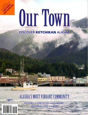
- Historical and current facts, Governments, Utilities, Climate, Chronology, etc.
- Attractions, Native Culture, the Visitor Industry, Churches, The arts, etc.
- Historic Ketchikan: neighborhoods, rehabilitation projects, etc.
- The forest & resources, mining, hunting, recreation, etc.
- Waterfront (USCG, shipyard, port, etc), hospital, wildlife, fishing, etc.
- Demographics
Be sure to pick up a copy during your visit!
More Ketchikan Information...
Home | Ketchikan Maps | Ketchikan Walking Tour Map









New! Comments
Have your say about what you just read! Leave me a comment below.